Ma On Shan (Saddle Hill) - is ranked 10th highest Mountain Peak & The Hunch Back (Ngau Ngak Shan) - is the 9th highest Hill in Hong Kong. There are numerous entry point to get to the summit of this fascinating Mountains. The easier approach would be at the right side of the barbecue park of Ma On Shan Tsuen and head towards Ngong Ping via Ma On Shan Country Trail and connect to MacLehose Trail Stage 4 in reverse mode. In this manner you will meet the Pyramid Hill (536masl) on you initial approach and you might want to visit the summit of it while you at it.
The aggressive or difficult approach would be on the left side of the Barbecue Park and it will require a higher degree of fitness and experience in hiking, bouldering & climbing. There's also some rope climbing and bushwacking involve.
TRANSPO:
- Take the MTR and head towards Ma On Shan Station.
- Leave by Exit B at Sunshine City Plaza and head towards the Bus station below.
- Take the mini bus 84R heading towards Ma On Shan Tsuen Barbecue Park.
- Alternatively, you can take the taxi to the barbecue park and it will cost around HK$60.
TRAIL INFO:
- Difficulty: 4/5 (On the right side), 5/5 (On the left side)
- Duration: 5 hrs to 5.5 hours
- Terrain: 90% Natural Trail & 10% Man-made Modifications
LOGISTICS:
- Around 25L - 30L Pack
- 2L - 3L of Water
- Food / Snack / Fruit / Power Bars / Energy Drink
- Ultra light weight & Multi-purpose clothing
- Hiking Pole (Optional)
- Gloves (A must, specially if you take the left route)
- Proper Hiking Shoes / Boots
- Sun glasses / Sun screen / Hat / Mosquito Repellent (Some could be optional)
- Extra Fresh Shirt (be sure to change the shirt after an enduring hike)
LET'S GO!
 |
MA ON SHAN TSUEN BBQ PARK
This will serve as a Starting Point or End Point depending on where you wish to start your adventure.
(The type of adventure that we did is: LOOP) |
 |
| The trail is very friendly with lot's of signage and I'm pretty sure that you won't get lost here. |
 |
| Take this route along side with the Country Park Management Office. See & Read what the green board says..."Enjoy Your Country Park" and I'm sure you will. |
 |
| Follow the route towards Ngong Ping but you need to get your eyes peeled on the sudden short cut to the right side of the trail. There will be an abandon house with lot's of creepy crawlers around it and you have to get there. |
 |
| Here is the abandon house with plenty of creepy crawlers around it. You need to hike on the right side of this abandon house. |
 |
| A refreshing pit stop along the trail...take a moment to freshen up or have some souvenir photo like what I did here. This is a really cold stream and I felt like jumping in it! |
 |
| Walk straight ahead and you will be under the shelter of this tress and a couple of meters ahead, there will be a resting area with a roof. |
 |
| A cross-road, you will need to go towards where the Pyramid Hill is (that hill up ahead). |
 |
PYRAMID HILL
Stands 536 meters above sea level. |
 |
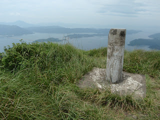
| This is the Summit Point (Trigonometric Point) of Pyramid Hill (536masl) and right down below is Sai Kung Peninsula. |
 |
| Head back down to the same place where you enter and summit the Pyramid Hill and proceed in the direction towards Ma On Shan. In this manner you are now tracing the reverse trail of MacLehose Trail Stage 4. |
 |
| This is the main attraction and mission of this trail...The Ma On Shan or also known as "Saddle Hill". |
 |
| The Summit Point (Trigonometric Point) of Ma On Shan 702 meters above sea level |
 |
| The HUNCH BACK (Ngau Ngak Shan) is the 9th highest hill in Hong Kong with the height of 674 meters above sea level and it is at the north side of Ma On Shan. |
 |
| In this section of the Ngau Ngak Shan (The Hunch Back) trail, there will be few experience of bushwacking and rope climbing involved. So prepare yourself for real adventure! |
 |
| This is the part where you need to wear those pair of gloves because you will be doing this rope climbing (apparently this guys are doing downhill in this photo). |
 |
| Some parts of the trail requires going down (or up, depending where you start your adventure) from this type of rocks. Be advise that you need to put on the glove because the rocks might be too sharp for your hands and fingers...but, I've tried not to put it on for better grip. |
 |
| This is the last part of the Rockies that you need to tackle on your way down (Be careful here!). Alternatively, there's a section on the left side of this rocks that may require less hard work than this area and there will be ropes to help you as you go down. |
 |
CALM AFTER THE STORM
This is where you can have a little bit of Break/Rest after enduring all that terrain. |
 |
END POINT / STARTING POINT
This will serve as the End Point if you start at the right side of the BBQ Park at Mao On Shan Tsuen and as well the Starting Point if you start on the left side of the BBQ Park.
All I can say is that no matter where you start it from - it will definitely share the same amount of extreme FUN!
Friendly Reminder
Enjoy Your Country Park, Enjoy Hiking and Leave No Trace! |


No comments:
Post a Comment